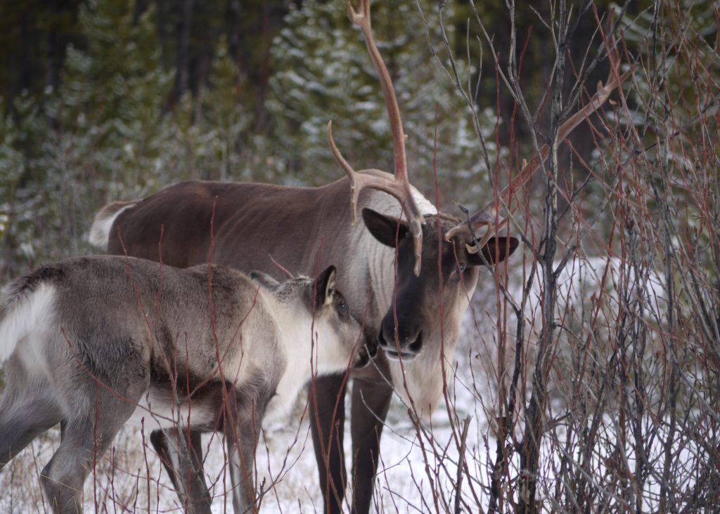
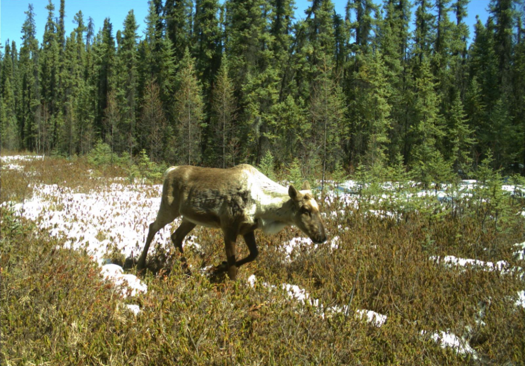
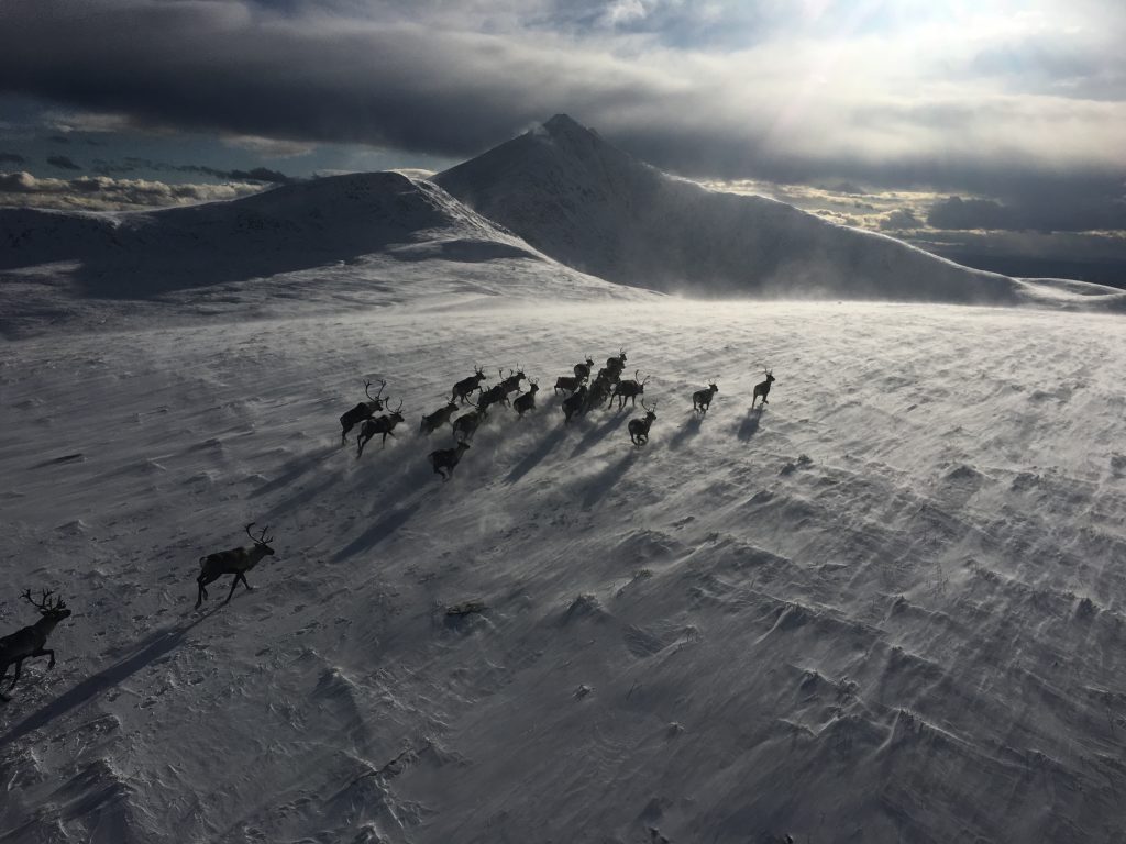
Caribou Recovery branding logo
Skip to navigation Skip to Contents Skip to Accessibility Statement
Search Menu
    [-] Peter

    Snowmobile Selkirk Pilot Project
    In collaboration with local stakeholders, we have developed an innovative approach for managing snowmobiling, and reducing impacts on Central Selkirk caribou. We developed a dynamic system to allow snowmobiling in areas of un-occupied habitat and prohibit snowmobiling in areas occupied by caribou by using GPS collar data to inform moving closures as the winter progresses. The system will use a total closure across the caribou range and then manage access through exemption permits.

    Under this system all caribou habitat in the Central Selkirks will be closed to snowmobiling year-round under the Motor Vehicle Prohibition Regulation within the Wildlife Act (Figure 1). This is the same legal mechanism as most snowmobile closures in the province, however, with one key difference. Access to the closed areas or management areas will be granted through exemption permits to two local clubs and their members (Arrow Lake Ridge Riders and Trout Lake Recreational Club). Members will have access to these exempted areas according to a web map, that will be updated daily, available via internet link. Closed zones within the management area will be determined by caribou locations via daily GPS collar transmissions. A condition of the permit will be that members are required log-on to view the web map daily before riding.

    Over the summer of 2019 government caribou biologists and local snowmobile club representatives developed this system. The system is a fully automated model that uses watershed boundaries, elevation and major geographical features to create zones that are turned off or on based on the presence or absence of caribou. We used 2 winters of GPS collar data to help understand the needs of the caribou and we use the location of riding areas and the access to riding areas to understand the needs of the snowmobile community. We made every attempt to create a model that would work for both caribou and snowmobilers

    [-] Justin

    This is going to close the main access route from the Murray FSR. The only way in with these proposed closures is through tentfire and the "42" drainage which is expert riding. The Easier route through Clubb Creek and "Rogers Pass" will be closed forcing everyone through the Wolverine FSR being forced to do water crossings

    [-] Justin

    There needs to be access through the closed area from North to South or this area will not be rideable. There is only one access route through a drainage to get into this area.

    [-] Trapper

    All Riding areas; With all the proposed closures i feel that this will negatively impact rider safety by forcing people to ride in smaller areas where as before they could spread out over many areas. This could become an issue and more difficult to manage especially when the avalanche danger is considerable to high. Rider safety is a key issue that should be managed properly and taken into consideration when proposing these closures…

    [-] Kirsten

    All riding areas: I am disappointed. I actively participated and reached out to others for input on the proposals in the past on this issue, and I feel that time after time, the What We Heard is not representing the voices of the general population in the north as a whole. With the proposed closures, I feel that rider safety will be negatively impacted drastically. The general rider will be forced to ride in smaller areas, increasing congestion as there are less areas to ride in. The loss of Silver Sands and Hasler, in particular, is a loss of HALF of the Chetwynd/Pine Valley Trail Blazers zones. That is huge. As a mom and wife, I go out for the day to ride safely. My group and I make sound choices that will take us home to our family at the end of the day. We avoid other groups that could compromise our safety. Implementing seasonal and/or full closures in two of our biggest riding zones is likely going to impact my ability to come home safely, especially when the avalanche danger is considerable to high. I will no longer have a safer zone like Silver Sands to make sound route choices in. As a progressing intermediate rider, I will be surrounded increasingly by more newer riders and advanced riders, which given less terrain ideal for their experience level, put me and my friends at more risk. The ability of various levels of riders to chose appropriate terrain is being taken away from us and we are all going to be forced to ride the same small areas. It is not an issue of unsafe riders, it is an issue of congestion. I was so happy to live in an area with increasing rider safety awareness, club membership levels and respectful riders, and also the presence of Avalanche Canada weather forecasters (due to the demand of riders in the area to provide an avalanche bulletin so riders can make even better informed decisions when out riding). Sadly, this is all going to seem to be for almost nothing.

    [-] Kirsten

    Hasler: Within our usual riding group of friends, yes, we have seen caribou in this area. However, if the caribou are being negatively impacted by snowmobile users then why are they they still being observed? Based on the proposed closure documentation put forth by the government, one would not observe caribou in the area if they were being negatively affected. Yet, we are seeing them. Therefore, the reasonable conclusion would be that snowmobilers and caribou can coexist in harmony?

    [-] Trapper

    Hasler; I understand why this area is subject to a seasonal closure as i have personally seen caribou in this area, my question is that if the caribou are being negatively impacted by snowmobiling why do they seem to stay in the area if there is snowmobile use in the area? Is it possible that caribou and snowmobilers could coexist in the area in harmony?

    [-] Kirsten

    Silver Sands/Mcnairn Flats/Carbon Creek/Upper Moberly: Why is there a closure here? The other proposed varying levels of closures appear to be based on elevation for caribou-related habitat. Regardless if I agree with those closures, they *could* make sense. This one does not. Why closures in the lower elevations? There is such a variety of terrain in this closure area (large open meadows, open navigate-able trees, large bowls and big mountain terrain) that it offers family fun, that is such a loss to those that call this place home. Many in Chetwynd and surrounding communities have moved here and chosen to stay based on the recreation activities they can take part in in this area. It will be a huge loss to the future of recreational activities for those that love this area. Why is there not more specific closures in this area, instead of a blanket massive area closed? In addition, the majority of this closure seems to appease a select group while restricting a large portion of the surrounding population. I do not feel it is fair to restrict access to one group and allow another. The whole user collective as a whole should be addressed.

    [-] Trapper

    Silver Sands / Mcnairn flats / Carbon creek Upper moberly;

    I have many mixed feelings about this area.

    I enjoy the wide variety of terrain this area has to offer, from big open meadows, open trees to large bowls and big mountain terrain. This area could be fun for family riding in the valley bottoms in the open meadows but this closure is unlike the rest proposed the low elevations are proposed to be closed as well.

    I have been riding in this area for multiple season and have seen caribou in this area and have respected their space, when we have seen them we have left them alone and gone back in the opposite direction they area traveling. So I respect why this area is proposed to be closed, But does all the terrain need to be closed or could there be a bit of give and take for this area.

    I feel like the majority of this closure is designed to appease a select group. Especially with how the boundaries are drawn through the lower elevations. Is this fair? to take one groups take on the issue over the user collective as a whole into consideration.

    [-] Trapper

    I feel like this area is a fair closure as the terrain is very difficult to access and is for the advanced rider.

    [-] Kirsten

    This closure is a reasonable one as it has difficult access therefore is not well used/rode except for the very advanced sledders.

    [-] Kirsten

    Pine Lemoray Enhancement: This area is a fantastic zone that would offer varied opportunities for riders or all levels. The reason this area can be ideal for all levels of riders is that there are lots of small rolling hills and open meadows which are easily navigated when the avalanche danger is considerable to high in the North Rockies. Advanced riders are able to find more technical terrain as well that can be ridden safely, as well.

    The access trail at the moment is from the Hasler F.S.R. and should be improved one of two ways to offer safer access: (1) improve existing trail as it is along a creek draw which can intimidate newer riders due to steep banks and open water below; or (2) develop a new trail access off of HWY 97 around Heart Lake. Putting in a new trail is the ideal solution given the additional proposed riding zone closures as the current trail requires users to travel appx 48km south along active F.S.R.s, only to then travel almost the equal distance back north towards the hiway. A new trail could also allow year round use such as a hiking trail in the summer to access the beautiful park.

    [-] Trapper

    Pine Le Morary; This area is a great riding spot with great opportunities for all riders, the access trail into here could use improvement as it goes up a creek draw to Otto Lake, this can be intimidating to new riders due steep banks and open water below. Once in the area there are many choices when it comes to terrain this is another area that has small rolling hills and open meadows that can be safely navigated when the avalanche danger is considerable to high for the region. This area also provides terrain to the advanced rides as well.

    The issue with this area is that it is very far back and you must travel considerable distances from the parking lot on the Hasler FSR. one way to improve this area would be to build a new trail from Highway 97 near Hart lake up to this area. This new trail could be a multi-use trail and utilized as a hiking trail in the summer to access the beautiful park.

    [-] Kirsten

    There is already a motor vehicle closure in this area above 1500m, however, signage is old and unmaintained. If the current closure cannot be effectively signed and managed, how is an expansion on this area supposed to happen? I feel this is going to be an issue in many of the new proposed closures. In my understanding, the government is expecting the local snowmobile clubs to ensure closures are followed, however, if there is nowhere valuable to ride memberships are not going to be purchased, then clubs are going to fold as the few members remaining are not willing to take on this task, and then what is left? Sounds like an easy way for the government to get rid of sledders altogether and there is a hidden agenda. I am not one to buy into conspiracy theories, but it is no secret that the public and government voices in the small land masses of the greater Vancouver area and Vancouver Island have all the power and think we are hillbillies up here that ruin the environment and shoot wolves for no reason. We live up here because we can recreate and enjoy the environment respectfully, and we want to continue to do this with our voices being heard.

    [-] Kirsten

    Grant Peak Area (Full Closure): This area should be divided into two sections instead of generalized as one large one as I am in full support of the Old Friend area closure as the caribou frequent this area based on the data provided,

    This area is highly sought after by advanced riders looking for more advanced and technical terrain and big mountain riding in the North Rockies. There is also some unique land features that would be difficult to see and enjoy in the off-season closures (summer) which is why winter access is such an attraction to this area.

    It is very important to note that there is limited users frequenting this area due to the advanced nature, therefore impact to the environment is very minimal.

    [-] Trapper

    Bullmoose/Chamberlain; This already has a motor vehicle closure above 1500m for the mountain goats in this area. This signage is dilapidated and not being maintained. As member of the public I find it embarrassing that the government is trying to bite off more then it can chew when it comes to actively managing animal recovery. To me this just shows that the government is not pre-paired to take on more challenges when it can not manage the efforts they currently have undertaken.

    [-] Trapper

    Grant Peak Area; This area should be broken down into two sections as i'm in full support of the old friend area being closed as the caribou frequent this area based off of the data provided.

    This area is a sought out area from the advanced users looking for more advanced terrain and big mountain riding. There is also some very neat land features that would be difficult to see during the summer months this is what makes snowmobiling such an attraction to this area. There is also limited users frequenting this area so the impact on caribou is very minimal.

    [-] Kirsten

    Watson Peak Area (Seasonal Closure): This area is not well used from what I am aware of. A full closure here would be reasonable. It was recommended by the South Peace Caribou Recovery group that this area could be closed in exchange to keep other well-used riding areas open. It appears that this recommendation has fallen on deaf ears as the government is closing this area as well as nearly every other riding zone in the North Rockies.

    [-] Trapper

    Watson Peak area; This area does not see much snowmobile use. A full closure here could be implemented to keep other areas that are more frequently used by snowmobile users a bit of give and take sort of deal. These recommendations where brought forward during the South Peace Caribou Recovery group meetings, but it seems that these recommendations fell on deaf ears. Its frustrating when volunteers try to see a picture from both sides and put hours into discussing issues and try to help come up with solutions and get neglected. It makes the engagement process not feel very engaging…

    [-] Trapper

    Hart Range Snowmobile closure; This closure was put into effect in 2000, when asked to be provided data on how this closure positively impacted the caribou recovery effort we were always told this data does not pertain to this conversation. As a member of the public i found this very frustrating as this information is pertinent in discussing future caribou recovery efforts because if this closure is not impacting the recovery why are we trying to close more areas to recreational users?

    [-] Kirsten

    Hart Range Snowmobile Closure: This closure was put into effect in 2000. When our snowmobile club asked for data on how this closure positively impacted the caribou recovery effort, we were told that this data does not pertain to this conversation. As a member of the public, I found this to be very frustrating as the requested information is very much so vital in discussing future caribou recovery efforts: if this closure is not impacting the recovery, then why are we trying to close more areas to recreational users???

    [-] Kirsten

    Old Friend (Full Seasonal Closure): This area is a reasonable zone for a full seasonal closure as the data available clearly shows frequent caribou presence in the area. The trail has begun to be overgrown by alders and without maintenance, will be increasingly difficult to access as time goes on.
    I am aware that this area will be logged, which is confusing that logging is being allowed in an area with active caribou while sledding is not. Recreational users are being blamed in this area for decreasing caribou numbers, however, we are not the only activity going on that affects habitat here. The overgrown trail is proof that sledders do not have a large impact on the habitat because it we did, the trail would not be overgrown. It would certainly make access to this riding zone easier and more enjoyable if it wasn’t, yet, us sledders navigate the trail as best as we can and let the bush overtake the trail. I am certain that this same care and respect for the habitat will not happen when it is logged.

    [-] Trapper

    Old Friend Full Closure; This area makes sense to have a full closure as the data clearly shows that the caribou frequent this area. This area is also getting difficult to access to to the trail getting over grown by alders.

    It saddens me to hear that this area is going to be logged. If caribou recovery is really to happen the habitat need to be protected. It is unfair that the government uses recreational users as a playing card to say they are helping the recovery effort. In my eyes this is unacceptable as the real issues is in the habitat. Snowmobilers do not negatively impact the habitat like logging does.

    [-] Kirsten

    Iver Lake: This lake is named after Iver Johnson, who was a pioneer to the area and ran a trapline for many years in the region around this lake. Iver sold this trapline, and then it was sold again to our friend's grandfather who knew Iver Johnson and was proud to take over the trapline and carry on Iver's legacy in the area. The grandfather had been a longtime resident of Hasler and has since passed away, with his grandchildren taking over operation of the trapline. My husband has his trapping license now and helps out our friend trapping this area. It is by far their favorite area to trap and they respect the land and fur management of the area as they want their children to be able to trap it far into the future and continue Iver Johnson's legacy in the area. Us and our friend's family visit the lake often as it is a beautiful point of interest year round, and is fish bearing so is excellent ice fishing. My 6 month old son is named is named after Iver Johnson and it would be very sad for us to not be able to take him to this lake and share this beautiful spot (sledding, fishing and trapping) with him as he grows up.

    [-] Trapper

    Iver Lake; This lake is named after Iver Johnson who was a pioneer to the area, who ran a trapline in the area of this lake. The trapline was purchased by my friends grandfather who ran this line for many years and has now passed away. He left this line to his grandsons who now carry on the family business of trapping. This area is a beautiful point of interest and is also fish bearing and a great spot to ice fish.

    I have named my son after Iver Johnson as i would like to teach him the old trade of trapping. I assist on this trapline with my friend who is the owner of the line and I would like to be able to take my son to this lake as he grows up. We use the snowmobiles to access this area for recreational and business use.

    [-] Kirsten

    Hudette Range (Full Seasonal Closure): In the data I have been able to find, there seems to be conflicting information regarding the frequency of caribou in this region. As far as snowmobile use in the area, a full seasonal closure would not affect riders as I am not aware of anyone that rides here regularly for recreational use. However, a friend owns the trapline in the Hudette range and it would be detrimental to his business if he could not use a snowmobile to access the trapline.

    [-] Trapper

    Hudette Range Full closure; I have seen conflicting data with this area over the years following the caribou recovery program. Some data is saying the caribou do not frequent this area or use it and other data says they do. I find this to be very confusing.

    This area is also part of my friends trapline which i assist on with him. Will this closure affect our ability to use snowmobiles in the area? If so this would be detrimental to our business.

    [-] Trapper

    Silver Sands Active management area; This area is a great area for families to ride in as there is limited exposure to avalanche danger, being an avalanche technician i feel that the user group responsible for managing this area may not take the avalanche danger rating into consideration for the region. This area is used heavily when the avalanche danger is considerable to extreme in the region. This is because the area is mostly flat with lots of meadows and open tree riding. closing this area might force the public to ride in areas that might put them at extra risk as they can not go to the area they feel safe to ride in.

    Some volunteers from the pine valley snowmobile club donated time and equipment to groom the trail up to the cabin to make it even more family friendly as this part of the trail can get extremely rough by mid season. This also makes access and egress safer for emergency use if need be. The warm up/emergency use cabin up there is also looked after by the pine valley snowmobile club and provides a nice place to stop for families.

    [-] Kirsten

    Silver Sands (Active Management Area): This riding zone is a huge loss to the snowmobile community as it is a SAFE (limited exposure to avalanche danger) area for families, riders unfamiliar with the North Rockies terrain, and both new/experienced riders. It is large enough that groups can spread out and not cause concern to others. As an intermediate rider, Silver Sands was a great area for me to learn how to ride and to learn/advance new skills. In particular, my husband and I could go in just the two of us when I was a newer rider and feel confident that we would be able to navigate the terrain and ride safely. My riding group is usually my husband and a few of our friends (my husband and one friend are Canadian Avalanche Association (CAA) Operations Level 1 trained, and all of our riding friends are at least Avalanche Canada AST1 trained) and we are aware that the avalanche danger is considerable to extreme in North Rockies region in general, so when the avalanche danger is on the higher end, Silver Sands is always our riding zone of choice as it is the safest option.

    The Pine Valley Trail Blazer Snowmobile Club has a day use/emergency cabin in the area as well. This cabin makes the area a great spot for family groups, is well stocked and maintained thanks to volunteer club members. Users of the area respect the cabin and keep it and the surrounding area clean for future users.

    In addition, the Pine Valley Snowmobile Club was able to arrange for two members to volunteer time and equipment to maintain the trail in to the riding zone. Historically, the first 7km of the trail is quite rough, however, the volunteers kept it smooth and made access in/out of the area safer and easier. In case of an emergency, anyone needing to sled the trail could likely cut their time on that first 7km from 45min down to 15min thanks to the grooming and lack of whups on trail. This added a lot of value to riders in the area, especially those groups with new and young riders.

    Overall, any loss of access to this area in the winter season would severely impact riders.

    [-] Kirsten

    Mt Bickford: I agree that this closure is reasonable. Due to the past penning program that operated in the area, the main access trail was decommissioned to the state where travel is difficult. At the time of the penning program operating in the area, the Pine Valley Trail Blazers snowmobile club ensured that snowmobilers stayed out of the area and respected the program and high concentration of caribou in the area. It was a loss for snowmobilers at the time as it was close-to-home riding area, especially that worked 9-5 jobs and wanted a few hours of riding after work. However, the closure was well-respected and riders understood and agreed it was the right thing to do, especially since there were many more areas to ride with less caribou-related conflicts. It was also a small riding area and constrained to one smaller mountain range.

    [-] Trapper

    Mt Bickford; This closure makes sense as the caribou penning program was operating out of this area and the main access trail was decommissioned to the state where it made travel very difficult. There was also a unofficial agreement that snowmobilers stay out of this area as they were operating this program up there and there was a high concentrate of caribou in the area. A lot of the public and recreational users respected this unofficial closure. This was communicated to the users by the Pine valley snowmobile club. This area was also very small and constrained to one little mountain range so it was not a significant loss as there was many more areas to ride with less conflict with caribou.

    [-] Kirsten

    The closing date for the partial seasonal closure of this area (Upper Burnt) is unreasonable for users. The access trail to this zone does not receive enough snow until mid January. The Pine Valley Snowmobile Club has maintained an emergency shelter in the riding zone for users as the access is far from a truck access road. This shelter has been well maintained on a regular basis and is easy to find for new users to the area if there was an emergency. Financial investment, both personally donated by members and the club, have ensured the cabin is stocked with emergency supplies. The loss of use past January 15th of this riding zone would mean all this effort has been wasted.

    [-] Trapper

    A partial seasonal closure in the upper burnt area for the time that is allotted is not great as the snow levels are not deep enough to access the area until mid season and that is when the government is suggesting the area be closed.

    The Pine valley snow mobile club (Chetwynd) has also invested in infrastructure to provide a warming/emergency shelter as the area is very remote. Closing the area would limit the club on the resources that they have worked hard on getting and putting out there for the public to use.

    In my many years of riding this area i have not seen any caribou or sign in this area. So this partial seasonal closure does not make any sense to me.

    [-] Dereck

    I have been riding silver sands for a decade and I myself have never seen caribou in that area. I do believe that the areas that the caribou are in we should work on sharing the land with them and all the other wild life.

    [-] Victor

    Zone 7- 31should remain open, especially to ATV use in the summer/fall seasons for recreational use by campers and hunters. This region is a traditional recreational area for the residents of Fort St. John and Hudson's Hope.

    [-] Walter

    no llichen left on trees when all the trees are gone

    [-] Clinton

    What will the enhancement be? The provincial government needs to step up with a dollar figure.

    [-] Clinton

    This closure removes most of the best riding areas in Beaver Creek. As well, the areas that remain open under this plan are some of the highest risk avalanche areas. This closure puts local resident's safety at risk

    [-] Clinton

    This seasonal closure will result in loss of use in the Upper Burnt riding area. The club will not put the time and resources required into maintaining the access trail for 2 weeks a year of riding.

    [-] Clinton

    This closure is on areas not occupied by any KDE data. Why the closure? The principle of active management should be to adjust management as caribou use and needs change. This closure is unnecessary and an attack on local snowmobilers.

    [-] Clinton

    In the context of how much of the Silver Sands Area is under a full season closure, this active closure is completely unnecessary and difficult to manage. This closure should be removed to provide some semblance of a quality snowmobile opportunity once everything is finalized

    [-] Clinton

    This thin strip of active closure bordering on the full closure makes no sense and will be very hard to monitor.

    [-] genevieve

    I do not support this closure. This area offers amazing riding opportunity, with great support to the local economy of chetwynd, powder king and mackenzie. much of this area's riding is extremely valued to snowmobilers.

    [-] genevieve

    I do not support this elevation closure. This infringes on a critical access trail for the wolverine riding area.
    I support the SPSAC recommendations.

    [-] genevieve

    Why no closures here? But active caribou data?
    I support the SPSAC recommendations.

    [-] genevieve

    I do not support the elevation closure. it is too generalized for this area (lets be honest, all areas), and includes vast riding areas that are inhabitable to caribou, due to its steepness/winter access points. and a major loss to the snowmobile community. I support the SPSAC recommendations.

    [-] Genevieve

    I do not agree that this should be a closure area. There is ample opportunity to have the co-existence of caribou and snowmobilers within this area and to still obtain safe riding. I stand with and support the SPSAC recommendation for this area. I believe it has great potential for sledders and the town of tumbler ridge.

    [-] Brian

    This entire ridge is an active riding area.

    General comment about entire proposed closure areas is that they seem to be protecting habitat and or potential habitat as apposed to areas that the caribou are actively using. Almost all the groups of caribou in the South Peace have individuals in the group that are collared with GPS tracking so the seasonal use of by any particular herd of group within the herd is well documented. There are many years of data available to show were the caribou are using any particular habitat. The proposed areas seem to be much larger that the current use by caribou. I would much prefer to see those critical areas where caribou now live be identified, protected by a full closure from all uses, industrial and recreational. These critical areas should then be further protected by establishing buffers to around them to keep snowmobiles away and to allow for expansion of the use by caribou out of the critical areas as populations recover. I am very familiar with the active caribou locations having worked for many years in caribou recovery and before that as a Forestry Planner in the South Peace. You would get much better buy in if people thought that the closed areas were actually protecting existing populations and not just habitat.
    There also needs to be some flexibility in the process and the need to evolve the program as time goes on. The current proposal seems to be taking everything despite that much of the area doesn't currently have caribou use.

    Much of the area proposed for caribou closures is currently covered by Coal, Forest, Gas and Petroleum, Wind Energy and Pipeline Tenures. My gut feeling is that the recreational closures are a soft target and are only being put forward to show the Federal Government (who are threatening to issue orders to Protect Endangered Species if BC doesn't come up with a plan acceptable to the Feds.) that BC is doing something to protect caribou. I am aware that there have been some curtailments for Forest Harvesting operations but unless other tenures area addressed (buy backs amendments etc.) then it does not make sense to have coal exploration on a ridge that we aren't allowed to snowmobile on.

    The Caribou in the South Peace do not have homogenous use of habitats. Some live all year around on a very localized area (example – Mount Speiker/Perry Creek at the lower end of the Wolverine Drainage), some migrate from winter to summer ranges (Example – Low Elevation Bearhole Lake herd winter in the Bearhole area and a portion of these animals summer in the McGregor and Framstead drainages. Point is that I would like to see herd specific actions that are tailored to their use of their habitats.
    In most of the South Peace where we have caribou, we have lower snow levels and more wind swept habitats than the caribou habitats in the Prince George and areas further south. The caribou in the South Peace tend to be Terrestrial feeders whereas the caribou in the Interior all the way south to the Kootenays tend to be Arboreal feeders and either crater through the snow or eat lichen out of the trees.
    I think that all the suppositions and assumptions about snowmobile/caribou interactions and their outcomes in BC are based on the experiences and research that we have with caribou that use their habitats in entirely different ways. I think that we need to plan and monitor our local herds and the ways to protect them based on local conditions, knowledge and use the 20 years of data that we already have. I have noticed from looking at the location data that many of the traditional locations for caribou overlap or neighbour snowmobile use and that has not changed over time. So in places like Big Boulder Creek/Silver Sands Creek there has been a long history of caribou and snowmobile use in the same areas. The caribou have not left these areas due to snowmobile use. In fact due to increase of caribou populations coming from the Maternal Caribou pen that operated in Fisher Creek there are now more caribou in one of the most heavily used area by sledders in the South Peace. They are not leaving and have a strong affinity to this location. There is some avoidance by caribou from open cutblocks in this area but they are often only a few hundred meters above the cutblocks.
    I would like to see a science based protection plan tailored to local data and habitats that would look different than the total closures proposed, and which in the your proposed plan seem to be mirror to the Arboreal based protections in other parts of the province.
    Thank you for your time,
    Brian Pate

    [-] Tim

    The protection of critical caribou habitat in the expanded Klinse-za Protected Area is an important step forward in the recovery of this iconic animal, and the restoration of rights guaranteed under Treaty 8. Y2Y supports this measure.

    [-] Chris

    Why are the closures primarily Centered on snowmobile riding areas? Why are the First Nations people involved with this proposal? This should fall in the fish and wildlife officers jurisdictions. This seems like a land grab that is more about power and land control than saving Cariboo.

    [-] Ryan

    Much of the proposed area for restrictions and closure are prime safe riding areas ( free from avalache risk and low consequence if mistakes are made). This not only forces riders into more dangerous terrain but also gives novice and young riders less safe places to learn and practice. I have been an avid user of the areas along the pine pass and south west of tumbler for the past 18 years. I have never in all those years seen even a single caribou in theses areas. I also, in all those years, have never acquired a membership to any club or organization that represents snowmobiling or atv's. I know that most people I ride with have never acquired memberships either. This being said, I don't understand how anyone could know the amount of people using these areas and the size of the economic structure that users of these areas have created.

    [-] Jeff

    There are no caribou here. Why would you close an area where there are no caribou??

    [-] Mathew

    I have been snowmobiling this area for the past. 15 years. I have never once seen a caribou. We live in this area because of the winter and summer activities. We have invested all of our hard earned money into snowmobile’s, boats, campers and other outdoor activities. If you take this away from us, be prepared to pay millions to all of the people that have invested all of their hard earn money on outdoor sports.

    [-] Trysha

    Removing any riding areas in the Pine Pass is going to force everyone to travel out of the area to ride. This means pushing all tourism further south (where they are already heavily populated and flooded with tourism). This does not encourage anyone to travel to our zone outside of skiing, and skiing is fairly limited based on the single ski hill.
    I've been riding in the pass for 4 years now and have never seen so much as a sign of any wildlife in the Bijoux Falls area. Even when we've branched off away from the trail, there has never been anything to indicate any wildlife inhabit the area whatsoever.

    [-] Trysha

    The proposed enhancement area for Morfee Mountain in Mackenzie BC is detrimental to family activities, as well as the only economic benefit our tiny town has for a short period of the year. The proposed area would eliminate the trail use to the brand new cabin that was made specifically for family rides, as well as completely removing any backcountry riding that draws people to travel to our small town. Sledders stay in our hotels, eat at our restaurants, and boost the economy all through the winter months. If this zone were to disappear it would destroy the economy, as well as completely deplete the morale in town. Sledding is a staple winter activity for many families, and is a huge part of what gets many through the long, cold winter months.

    [-] Alain

    This closure would meen that I will no longer be coming to your province and support your local businesses. These are areas that I have enjoyed for many years and with this closure, I'd have no reason to come and spend my money in your province.

    [-] Alain

    I enjoy this area during the winter months snowmobiling. With this closure I will have no reason to come to this area and support local business. I come from out of province and will no longer be spending my money in your province

    [-] Alain

    These closures affect winter activities in this area. I come from out of province to enjoy this area and spend money in the local towns. Closing this area will mean that I will nolonger be coming and spending my money, in your province.

    [-] kevin

    We need to consider the impact that theses restriction will have on the people that actually live in the area. 300 caribou whose population is on the incline dose not require such drastic measures. to restrict the lively hood of those who truly enjoy the outdoors when we could just increase funding to the current measures in place is ridiculous

    [-] kevin

    As an aboriginal local to the area, I am against theses restrictions 100%.

    [-] Crystal

    Please don’t shut down this area for recreational use. It’s an amazing place to explore and draws in may people which Tumbler Ridge benefited greatly from.

    [-] Luke

    I love to explore the backcountry around tumbler ridge and pine pass year round and with the all the proposed closure areas it leaves many like me feeling forced to quit, I do not believe it to be fair for us especially the powder king area where there are so many users of that land from backcountry skiers and snowmobilers.

Comments are closed.