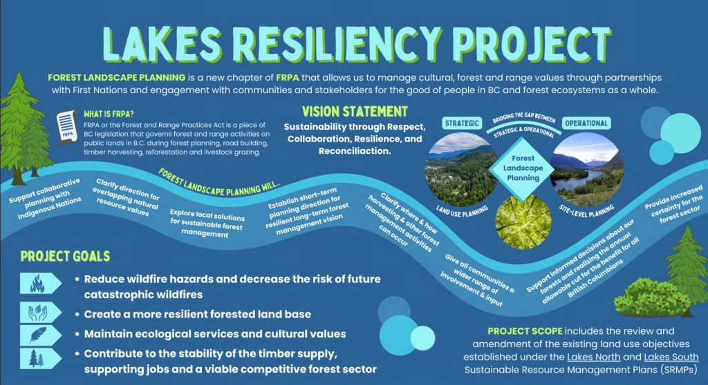
Lakes Resiliency Project
On this page…
open
Survey is open until July 31
Overview
Who: The Ministry of Forests
What: New land use objectives and forest management plans for the Lakes planning area
Where: Lakes Timber Supply Area (TSA), Skeena Region
Why: To modernize and improve land use practices
How: Online
Background
The goal of the Lakes Resiliency Project (the project) is to develop direction for sustainable forest management in this area of the Skeena Region. This Forest Landscape Plan (FLP) has been developed in collaboration with First Nations and licensees with input from local communities and stakeholders in the planning area. The planning area is within the Lakes Timber Supply Area (TSA).
This plan is one of four pilots for other areas in the province. The Lakes Resiliency Project will:
- Amend the Lakes North and South Land Use Objective Orders (LUOO)
- Produce a forest landscape plan that aligns with the new changes to the Forest and Range Practices Act and reflects the interests of First Nations, licensees, local communities, and the public
We want to hear your comments or concerns on the proposed draft Forest Landscape Plan and land use objective amendments.
The project’s vision statement is: Sustainability through respect, collaboration, resilience, and reconciliation.
Forest and Range Practices Act
The Forest and Range Practices Act (FRPA) is B.C. legislation that governs forest and range activities on public lands during forest planning, road building, timber harvesting, reforestation, and livestock grazing. Forest Landscape Planning is a new chapter of FRPA. It allows us to manage cultural, forest, and range values through partnerships with First Nations and engagement with communities and affected parties for the good of the people in B.C. and forest ecosystems.
Forest Landscape Planning will:
- Support collaborative planning with Indigenous Nations
- Clarify direction for overlapping natural resource values
- Explore local solutions for sustainable forest management
- Establish short-term planning direction for resilient long-term forest management vision
- Clarify where and how harvesting and other forest management activities can occur
- Give all communities a wider range of involvement and input
- Support informed decision about our forests and realizing the annual allowable cut for the benefit for all British Columbians
- Provide increased certainty for the forest sector
Project Goals:
- Reduce wildfire hazards and decrease the risk of future catastrophic wildfires
- Create a more resilient forested land base
- Maintain ecological services and cultural values
- Contribute to the stability of the timber supply, supporting jobs and a viable competitive forest sector
The project’s scope includes the review and amendment of the existing land use objectives orders established under the Lakes North and Lakes South Sustainable Resource Management (SRMPs).
Current conditions report engagement
In 2024, The Lakes Resiliency Project sought public review and comment on the current condition report for the Lakes planning area. The current condition report identifies:
- Current forest management practices
- The impact of those current practices
- Natural disturbances on the landbase
Read the current conditions report (PDF, 8MB)
Read the current conditions report summary (PDF, 500KB)
View the results of this engagement
Engagement summary and how to participate
This engagement is on the Forest Landscape Plan and Land Use Objectives Regulation Orders (LUOO) amendments within the Lakes Resiliency Project area. Visit the project page for more information on how to participate, including the online survey.
LUOO amendments and FLP strategies
The FLP is large and covers many areas of different technical complexities. It includes 5 proposed LUOO amendments and 9 FLP sections with 28 proposed strategies. You can read the full-length plan (PDF, 7.4MB) or review additional background information on the project site. These are also available to review in person at:
- The Nadina Natural Resource District office in Burns Lake, 183 Highway 16 West
- Smithers Regional Office in Smithers, 3726 Alfred Street
LUOO amendments: key changes proposed
Seral stage definition
Seral stage describes a distinct phase of forest development that occurs within the natural process of ecological succession following a disturbance. After events such as a wildfire or harvesting, the area gradually changes over time from bare ground with moss to grassland, then to shrubs and eventually into a mature forest. Each of these steps is a seral stage, with the mature forest representing the climax stage.
The planning area includes two major biogeoclimatic ecosystem zones: Englemann spruce subalpine fir (ESSF) and sub‑boreal Spruce (SBS). The ESSF ecosystem transitions from the lower elevation SBS ecosystem.
The two ecosystems currently use different age thresholds to define mature and old forests. In the SBS zone, forests are considered mature at more than 100 years old and old at more than 140 years. In the ESSF zone, forests are considered mature at more than 120 years and old at more than 250 years.
New seral stage definitions are being proposed to replace definitions from the 1995 biodiversity guidebook. These updated definitions use more recent information and would make the age definitions the same for both ESSF and SBS ecosystems. The revised seral stage definitions explicitly recognize and account for the ecotonal characteristics of the ESSF BEC zone. Ecotonal meaning the transitional area where two distinct ecological areas meet and overlap.
Under the proposed changes, forests in both ecosystems would be classified as mature at 80 years old and old at 140 years.
Seral stage targets
Seral stage distribution refers to the proportion and spatial arrangement of forest area across different seral stages within a defined landscape. This objective is to make sure there is a healthy mix of young, mature and old forests within each landscape unit and biogeoclimatic zone.
Accordingly, seral stage distributions were redefined to reflect natural disturbance patterns of a fire-based ecosystem as found within the Lakes TSA.
Stand-level retention
Stand-level retention focuses on retaining key ecological structures, habitat features and riparian areas within harvested areas to retain biological characteristics and improve habitat quality in regenerating stands.
Feedback from First Nations highlighted the importance of increasing wildlife tree retention. The proposed amendment increases the Wildlife Tree Retention Area amount and harmonizes it across the TSA rather than varying by ecosystem.
Patch size distribution
Patch size distribution measures how much of the landscape is occupied by very early seral stages, defined as areas 20 years old or younger. The distribution of patch size in forest disturbances is a critical aspect of forest management and biodiversity conservation.
Current practices have created a fragmented landscape that is more susceptible to natural disturbance. The proposed patch size distribution aims to reduce fragmentation and reflect natural disturbance patterns of a fire-based ecosystem as found within the Lakes TSA.
Old growth and connectivity
Old growth management areas (OGMAs) are areas set aside to help meet targets for old forests. These areas include forests of many different ages, and many do not meet the current definition of old forest. Younger forests within OGMAs are usually the result of natural events, such as wildfire or mountain pine beetle outbreaks. Mid-aged and mature forests were intentionally included so they can grow into old forest over time.
The landscape connectivity matrix (LCM) is a network of forest corridors designed to keep wildlife habitat connected throughout the landscape. While it supports connectivity, the LCM creates operational challenges, including limits on dead timber salvage and reduced ability to manage wildfire risk.
Under the LUOOs and FLP framework, both OGMAs and the LCM will be replaced by the Lakes biodiversity matrix. This new approach is intended to maintain important habitat areas and landscape connectivity, while providing greater flexibility to manage wildfire risk and respond to natural disturbances.
The biodiversity matrix will be guided by clear objectives, targets and rules that define what activities are allowed. This will help licensees manage large‑scale natural disturbances while still meeting biodiversity goals.
FLP draft: key strategies proposed
Cultural well-being
The cultural well-being strategies addresses First Nations’ cultural relationships and practices on the landscape. Ensuring that there are healthy ecosystems that support food, social, ceremonial and economic needs.
Landscape ecosystem health and resilience
The landscape ecosystem health and resilience strategies aim to address forests that have become too fragmented, too uniform and lacking the natural mix of ages and ecosystem diversity.
The strategies guide a shift toward landscape patterns that reflect natural processes. This is accomplished by strengthening ecosystems, improving forest connectivity, rebalancing seral stages and allowing for longer recovery periods following a disturbance. They use a connectivity matrix to support a more dynamically managed forest, recognizing uncertainty through adaptive management and ongoing learning, while prioritizing natural processes and important ecological and cultural values.
Wildfire resilience
Wildfire resilience strategies respond to the concerns of increasing size and intensity of wildfires by proactively shaping forest conditions in key areas of the landbase. Rather than trying to suppress a fire entirely, these strategies focus on reducing extreme fire behaviour and improving response opportunities. This is done by managing forest fuels, adjusting harvesting and regeneration practices, and working with natural landscape features to slow fire spread. This approach is especially important given the legacy of fuel buildup from past disturbances and the growing influence of climate change on wildfire behaviour in the planning area.
Aquatics, wetlands, and riparian habitat
The Aquatics, Wetlands and Riparian Habitat strategies focus on protecting and restoring water-dependent ecosystems that have been heavily affected by insects, wildfire, roads and salvage activities. These strategies prioritize maintaining near natural hydrology, stream stability, water quality, fish passage and wetland function. They also place strong emphasis on working directly with First Nations to identify and protect culturally important aquatic and riparian areas. This ensures that watershed health and cultural stewardship are addressed alongside forest and wildfire management.
Wildlife habitat
The Wildlife Habitat strategies are focused on maintaining healthy, connected and resilient ecosystems over the long-term. This is done by providing direction on road and forest development so that these activities do not fragment habitat or degrade the environment, which changes animal movement. The strategies will prioritize management for these values as a practical way to reduce industrial impact while still allowing harvest opportunities.
Visual quality
The Visual Quality strategies guide how forest activities should look so they blend naturally with the landscape. In areas like the Lakes TSA, where wildfire and other large-scale natural disturbances are common, visible changes to the landscape are a normal part of ecosystem dynamics. Rather than trying to maintain a uniform or undisturbed appearance, these approaches recognize that change is inherent in fire-driven systems and instead focus on designing forest practices that reflect natural patterns and processes.
Range
The range strategies keep rangelands and forests healthy, while supporting livestock, wildlife and forestry. They ensure grazing stays within what the land can naturally recover from, protecting soil, water and plant health.
They also maintain diverse, connected habitats for wildlife and co-ordinates grazing with forest activities. In addition, the strategies work to prevent invasive plants from spreading from activities like harvesting, hauling and ground disturbance by focusing on early detection and quick response.
Soil
The soil strategies are about protecting soil as the foundation of healthy forests and ecosystems. They guide forest activities to limit soil damage like compaction, erosion and disruption of natural water movement. This is especially important in sensitive, unstable or wet soils because keeping soils intact helps support plant growth and protects long‑term productivity.
The strategies also focus on protecting wetlands, riparian soils and natural drainage to keep water clean and flowing properly. They reduce long‑term impacts by limiting new roads, sharing access where possible and restoring or closing old roads that affect soil and water function. By combining careful planning, monitoring and Indigenous knowledge, the strategies support healthy soils, clean water, wildlife habitat and resilient ecosystems over time.
Timber and harvesting levels
The timber supply strategies focus on maintaining a sustainable and resilient supply of timber in the Lakes TSA, while responding to climate change, past disturbances and current forest conditions. They guide where and how harvesting takes place, so that productive forest land is maintained over the long term.
Under the FLP, this is achieved through a flexible, landscape-level approach that maintains access to a broad harvestable land base and manages harvesting within objectives for old forest retention, disturbance patterns and wildfire resilience, resulting in a projected sustainable harvest level of approximately 620,255 cubic metres of green timber across the FLP area.
Together, these strategies highlight key priorities within the forest landscape plan and demonstrate how the plan is responding to the most significant risks and values in a highly disturbed and fire-affected landscape.
Strategies at a glance
This list provides a one-sentence summary of what each strategy is about:
- Strategy 1: Lakes Biodiversity Matrix — Keep a connected network of key habitats with limited harvesting to protect nature and cultural values long term
- Strategy 2: Seral Stage – Old Forest — Keep a better mix of forest ages, especially mature and old forests, so habitat and connectivity stay balanced
- Strategy 3: Patch Size — Use larger, more natural-looking harvest patches to reduce fragmentation and better match wildfire patterns
- Strategy 4: Stand-Level Retention Across the Standard Harvest Area — Leave more important trees and habitat features inside cutblocks to support wildlife and recovery
- Strategy 5: Focused Harvest Area (FHA) — Concentrate harvesting in one area for a short time to mimic wildfire and reduce widespread fragmentation
- Strategy 6: Interim Recovery Areas (IRA) — Set temporary “rest areas” with low human activity so ecosystems can recover
- Strategy 7: Wildfire Threat within Interim Potential Operational Delineations (POD) — Reduce continuous fuels inside POD areas so fires spread less and firefighters can work more safely
- Strategy 8: Fuel Management and Mitigation Near Potential Control Features (PCF) — Strengthen roads/rivers/ridges as fuel-reduced boundaries to help slow or stop wildfire
- Strategy 9: Fuel Management and Mitigation Activities within Wildland Urban Interface Areas (WUI) — Treat fuels near communities to reduce fire intensity and protect people and property
- Strategy 10: Riparian Habitat — Keep healthy streamside forests for shade, stable banks, water quality, and fish/wildlife habitat
- Strategy 11: Road Practices Near Wetlands — Build/manage/close roads near wetlands to protect water flow and prevent sediment harm
- Strategy 12: Watershed Disturbance — Limit overall watershed disturbance so stream flows stay closer to natural and habitat stays stable
- Strategy 13: Open Road Density — Reduce open roads (especially in priority watersheds) to lower sediment and reduce wildlife disturbance
- Strategy 14: Protect Wildlife Habitat Features — Protect small but critical wildlife sites (dens, nests, licks, etc.) from disturbance
- Strategy 15: Moose Cover — Keep enough secure forest cover so moose can rest, stay warm in the winter and cool in the summer, and move safely
- Strategy 16: Moose Forage — Maintain good moose food areas near secure cover so moose can feed safely
- Strategy 17: Moose Disturbance — Reduce road/activity impacts that increase hunting, predation, and stress on moose
- Strategy 18: Fisher Habitat Retention Tool — Keep enough connected, complex older forest so fisher can den, rest, and raise young
- Strategy 19: Northern Goshawk Breeding and Forage — Protect nest areas and nearby feeding habitat so goshawks can reproduce successfully
- Strategy 20: Caribou — Increase intact habitat and keep the forest age mix needed for caribou over time, following legal direction
- Strategy 21: Mountain Goat — Reduce disturbance and protect key winter range terrain and cover for goats
- Strategy 22: Mule Deer — Protect older forest winter range that helps deer conserve energy and stay safe in deep snow
- Strategy 23: Grizzly Bear — Keep large, connected areas of suitable habitat and limit major forestry in key habitat polygons
- Strategy 24: Visual Quality — Design forestry to look more like natural wildfire patterns, especially in scenic view areas
- Strategy 25: Natural Range Barriers — Avoid damage to natural landscape features that control livestock movements within range tenures
- Strategy 26: Mitigate Spread of Invasive Plants — Prevent invasive plants from spreading through roads and operations using early detection and quick action
- Strategy 27: Mitigate Soil Disturbance — Reduce soil damage and road impacts to protect long-term forest growth and water quality
- Strategy 28: Timber Supply — Keep timber harvesting sustainable and resilient while balancing other forest values and climate impacts
Quick definitions
- Basal area: a way to measure how much tree trunk area remains, to estimate tree stand density (see “Forest stand”) or volume of timber
- Biodiversity: many different kinds of plants and animals living together
- Cutblock: a specific, authorized area where timber harvesting takes place
- Equivalent Clearcut Area (ECA): a way to estimate how much impacts to water movement cause forest disturbance as if the area was fully clearcut
- Forest edge: borders between forests and open areas
- Forest stand: a group of trees that are similar in age and/or condition, growing together
- Fragmentation: breaking big forest cutblocks into many smaller pieces
- Fuel break: a strip or area with less burnable material to slow fire
- Interior forest: deep forest far from edges and roads
- Matrix: a connected set of areas across a landscape
- Natural Range of Variability (NRV): what forests would normally look like over time with natural events like wildfire
- Retention: leaving some or certain trees and habitat features
- Riparian: land beside streams, rivers, lakes, and wetlands
- Seral stage: a forest “age step” as it grows back after disturbance
- Wildland-Urban Interface (WUI): where homes and forest/grass fuels meet
Results
- Current Conditions Report: What We Heard (PDF, 300KB)
- November 2025 to January 2026 Public Engagement: What We Heard (PDF, 2.4MB)
Related engagements