Kaska-B.C. Land Use Planning
On this page:
Please visit the Land and Water Planning website to read about the project and sign up for project updates.
Overview
Dates: July 2 to August 4
Who:
- Kaska First Nations (Dease River First Nation, Kwadacha Nation, Liard First Nation including Daylu Dena Council, and Ross River Dena Council)
- The Ministry of Water, Land and Resource Stewardship
What: The Kaska-B.C. Land Use Planning project
Where: North-Central B.C.
Why: To understand the values and priorities related to the project area
How: Online
Background and project area
Land use planning supports preservation of cultural values, healthy ecosystems, and opportunities for economic activities by setting broad strategic direction for plan areas — providing clarity for ‘what’ can occur ‘where’ on land and water. It is a transparent and inclusive process that can be modified over time to address changing needs.
The Kaska–B.C. land use planning project area includes the 9.9 million hectares of Kaska Ancestral Territory in B.C. It also intersects with Treaty 8 territories, as well as the traditional territories of several other rights-holding First Nations. In 2024, Kaska First Nations and the B.C. government (the project team) entered into a formal process agreement to work on two land use planning goals within the territory:
- Establish an Indigenous-led conservation area called Dene K’éh Kusān
- Complete land use planning (reviewing and updating) in areas outside Dene K’éh Kusān and existing parks, protected areas, and other conservancies
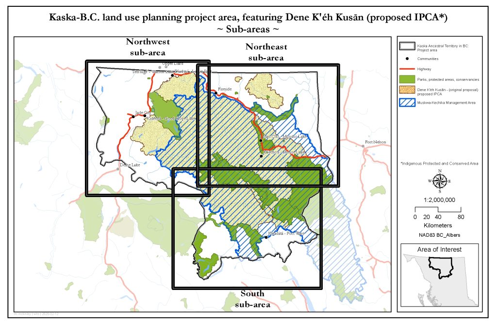
The area outside the proposed Dene K’éh Kusān conservation area has been divided into three sub-areas:
- Northwest: The Dease-Liard Sustainable Resource Management Plan (jointly developed by the B.C. government and Kaska, 2004 and 2012)
- Northeast:
- The Fort Nelson Land and Resource Management Plan (approved by the B.C. government, 1997)
- The North Liard Sustainable Resource Management Plan (developed and approved by Kaska, acknowledged by the B.C. government, 2016)
- South:
- The 2017 Kwadacha Nation Land Use Plan (developed and approved by Kaska, acknowledged by the B.C. government, 2017)
- The Mackenzie Land and Resource Management Plan (jointly developed and approved by the B.C. government and Kaska, 2000)
- The Cassiar Iskut-Stikine Land and Resource Management Plan (approved by the B.C. government, 2000)

Engagement summary
The purpose of this engagement was to gather feedback on:
- The updated boundary and intent of the Dene K’éh Kusān conservation area
- The proposed updates to the Dease-Liard Sustainable Resource Management Plan (SRMP)
The Northeast and South sub-areas do not currently have any proposed updates and are not included in this engagement opportunity.
The Kaska and B.C. are proposing to establish Dene K’eh Kusān as a conservancy. It will cover 3.1 million hectares of land within the project area. Conservancies are lands set aside under the Park Act for:
- The protection and maintenance of their biological diversity and natural environments
- The preservation and maintenance of social, ceremonial and cultural uses of First Nations
- The protection and maintenance of their recreational values
- Development or use of natural resources in a manner consistent with the purposes of the above
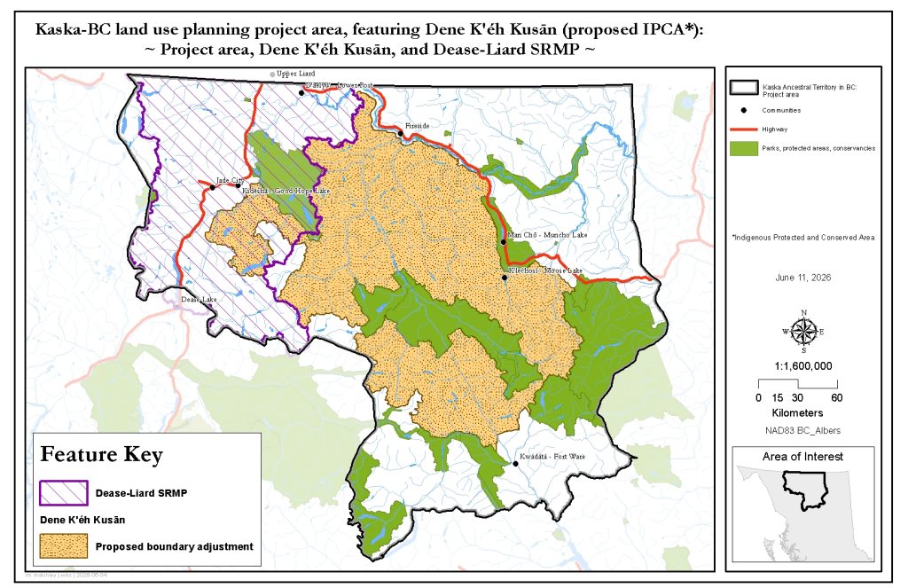
Proposed updates to the Dease‑Liard SRMP include:
- Boundary and zoning adjustments: Align the plan area and land use zones with proposed Dene K’éh Kusān and existing Ne’āh’ Conservancy boundaries. This will improve consistency and better reflect Indigenous land use priorities.
- Legal objectives: Keep the current legal objectives (PDF, 800KB), except for the legal no harvest restrictions in Timber Area B (PDF, 700KB). This will support small-scale community forestry and create more local opportunities, while still keeping sustainability measures in place. Keeping the existing objectives also provides more clarity for decision-makers and project developers.
- Integrated resource management approach (IRM): Use an IRM approach that considers all land uses across the landscape to better manage combined impacts, cultural values, and coordination. This approach brings together Kaska laws, knowledge, and cultural values with western science.
- Minerals and aggregates: Updating management direction while keeping the current zoning framework, improving clarity and predictability for development.
- Wildlife: Better management direction that responds to population declines and protects important habitats and sensitive seasonal periods. This will help species such as caribou, moose, and mountain ungulates (hoofed animals like goats).
- Riparian areas and large river corridors: New guidance on how freshwater systems are managed, including large river corridors (rivers wider than 20 metres). These corridors hold sacred and cultural significance and support many plants and animals. Management considers their features—such as floodplains, wetlands, and riparian habitats—and their importance for fish, wildlife, and plant species, as well as for Kaska trails, harvesting areas, sacred sites, and communities.
- Forest resources: Replacing the Timber section with a broader Forest Resources section, including carbon offset opportunities and supporting a wider range of forest activities.
- Expanded objectives, measures, and targets: Use more objectives, measures, and targets to address all resource development activities. This will better manage the main causes of ecological and cultural impacts.
Read the full plan (PDF, 23.2MB)
To learn more about the project and the proposed updates, please visit the Land and Water Planning in B.C. site.
Previous engagement
The Kaska-B.C. Land Use Planning (LUP) project asked to hear from community members, industry, local government, interested parties, and the public on their values and priorities, as well interest in specific land use planning activities in the project area.
Feedback received between June 2025 and March 2026 informed the development of a Kaska-B.C. Land Use Planning Project update document. A What We Heard report summarizes the perspectives, values, and interests submitted by stakeholders, communities, and the public during that time.
How your contribution makes a difference
Feedback from the survey will inform the final recommendations for the proposed conservation area and updated land use planning objectives. The results will be shared publicly ahead of seeking approval in late fall 2026.
Related engagements